Skip to content

Or try searching by Category and/or Location

In West Iceland you can find a lot of beautiful, breathtaking Waterfalls in various sizes and shapes. 

Klukkufoss waterfall hiking trail
Klukkufoss waterfall is located in Eysteinsdal in Snæfellsnes. The trail is quite short but challenging, where you walk up a steep hill to the basalt formed mountain Klukka and Klukkufoss waterfall falls amidst beautiful basalt colums formations. On the hike up to Klukkufoss , there is a chance to enjoy the view of the surrounding countryside, but the rock formations catch the attention of visitors along with the beautiful Klukkufoss. Klukkufoss hiking trail is one of 35 hiking trails that have been put up in the hiking trail brochure for the Snæfellsjökull National Park, and there you can find information about the km length of the hiking trail, the duration of the hiking trail and information about the markings on the hiking trail. When walking up to Klukkufoss, there is a view down to Öndverðarnes and Saxhól, together with the proximity of Snæfellsjökull and a view of the surrounding countryside.  Area: Klukkufoss, Snæfellsjökull national park.  Road number to the starting point: Útnesvegur (no. 574). Eysteinsdalsvegur (F575).  Level of difficulty: Moderate.  Lenght: 0.94km.  Elevation: 58 meters.  Markings: Markings are visable.  Duration: 13 minutes.  Route type: Lava field, grass and small rocks.  Obstacles: Steps are on the path.  Services in the area: No services.  Illumination: No illumination.  Season: The trail is open all year, but it is advised the the path may be slippery due to ice during the winter and the areais wet with mud during March until May.  GPS coordinates starting-and ending point: N64°52.1791 W023°51.6872 
Akranes forestry
At Akranes, you can find three fun hiking trails through forestries. One is in Garðalund, one in Klapparholt and one inSlaga. Garðalundur has a variety of recreational opportunities for the residents and visitors of Akranes, Klapparholt is a forest where you can find many different types of vegetation, such as birch and pine and at Slagi forest,which is located at the roots of Akrafjall mountain, where visitors can find different walking trails, along with different plant life and fantastic views over Akranes and Faxaflói bay.   In Garðalund you can find a variety of recreation for residents and visitors of Akranes. Volleyball court, frisbeegolf course, exercise equipment, resting places, cabin, walking trails and information boards. A flourishing social area, with infrastructure like toilets and garbage bins, where visitors can enjoy the many recreational options thatcan be found in Garðalundur.  Entering Klapparholt, you can find several information sign about the area and the couple Guðmundur Guðjónsson andRagnhildur Árnadóttir, who started cultivation and organization in the area in 1988. You can also find „Klapparholtið“, but it is in the middle of the forestry. There are stories that an elf church and hidden people live in the „Klapparholtchurch“ that stands there. It is popular for outdoor enthusiasts to use the area for walking, running or cycling.  In Slaga forestry you can find resting places and infrastructure like toilets and garbage bins, but is addition there is agreat view of Akranes and the surrounding area. There is a trail from Slaga to the starting path up Akrafjall, but it is also popular for outdoor enthusiasts to use the area for walking, running or cycling.   Area: Akranes  Road number to the starting point: At Garðalund (Klapparholtsvegur) inside Akranes.  Difficulty level: Easy. Accessibility for wheelchairs and wagons but on some trails, the accessibility is not available.  Length: 12.31 km  Elevation: 50-100 meters.  Markings: There can be found marking in some of the areas but not in-between the areas. The paths are very visible.  Duration: 2.23 hours.  Route type: Small rocks, grass and mixed material.  Obstacles on the way: No obstacles inside Garðalundur and Klapparholt but there are steps and difficult grass paths in Slaga.  Services in the area: At Garðalund and at Slaga.  Illumination: Some illumination between the forestries.  Season: The walking trail is open all year round.  GPS coordinates to the starting point: N64°19.3052 W022°02.2243. At Garðalund.  GPS coordinates to the finishing point: N64°19.9648 W021°58.8807. At Slaga.  
Hraunfossar, lava waterfalls in Borgarfjord
Hraunfossar - Lava Falls - are beautiful and unusual natural phenomena. Clear, cold springs of subterranean water seep through the lava and run as tiny waterfalls and rapids into the Hvita River. Hraunfossar have been protected since 1987. There is a viewpoint at the car park offering an amazing view over the Lava Falls and Hvita River. Restaurant and souvenir shop open all year round.
Fossatún hiking trail
Fossatún is a well-known destination in Borgarfjörður, where you can find hiking trails related to folklore heritageand troll books, written by the local keeper, where the stories are set in west Iceland. Fossatún is located in between large summer house areas, where Skorradalur and Húsafell lie on either side of Fossatún. Grímsá river runs nextto Fossatún and you can also find spectacular views of the mountain range of Borgarfjörður at Fossatún.   Fossatún is located about 90 km from Reykjavík, on road no.50, halfway between Borgarnes and Reykholt in Borgarfjörður. Different accommodation facilities are available at Fossatún, from campsites, cottages, guesthouses and country hotel. There is a restaurant as well as facilities for guests to cook, and everyone has access to hot tubs. Fossatún is located on the banks of Grímsá river and has hiking trails along the riverside area, but there is also a hiking trail to Blundsvatn lake, where you can find diverse bird life and a beautiful view of Borgarfjörður´s mountain range.  You can walk from the service area at Fossatún and walk along Grímsá river, where you can find information signs, including sign about the saga´s, legends and trolls. The trail is very visable and accessible for a wide range of guests. The trail to Blundsvatn lake is quite visable but the accessibility is not for as wide range of guests. Grass paths with someparts on gravel is located on the trails but the trail connects the Blundsvatn lake to the Fossatún area.   Area: Fossatún, Borgarbyggð.  Road number to the starting point: Borgarfjarðarbraut (nr. 50).  Level of difficulty: Easy.  Length: 1.75km trail at Fossatún and 3.13km at Blundsvatn lake. Together: 4.8 km  Elevation: 47 meters at Blundsvatn lake and 60 meters at Fossatún. .  Markings: Markings are visable, with information signs and rock formations plentiful.  Duration: At Fossatún is 32 minuets and Blundsvatn lake 40 minuets. Together: 1.2 hours.  Route type: Small rocks and mixed materials.   Obstacles on the way: No obstacles on theroute.   Service in the area: The main service/information house at Fossatún.  Illumination: No illumination.  Season: The route is open except when temporary closed due to bad weather over the winter time or due to bird nestingtime.  GPS coordinates to the staring-andfinishing point: N64°35.5672 W021°34.6263   
Glymur, waterfall in Hvalfjord
Attention - During winter the hiking path can be dangerous! Proper equipment and hiking experience is essential! Iceland’s tallest waterfall, is located in Botnsdalur valley, Hvalfjörður. Leading up to it is a fabulous hiking path that should only be attempted by those not daunted by heights or challenging hikes. Glymur is in the river Botnsá that runs out of Hvalvatn, which is a lake closed by molten lava, some 160 metres deep. In Hvalfjordur in West Iceland you can stand in awe before Iceland’s highest waterfall. Standing by the fall you'll have a good view of the surrounding landcape, which is is particularly attractive, as Hvalfjordur is widely considered one of Iceland's most beautiful fjords.The walk, approximately 4 hours roundtrip, will take you from the trailhead at Botnsa river through spectacular scenery including a rock arch and will have you crossing a crystal clear river on a strategically placed log.
Troll Waterfalls in Borgarfjord
The Troll Waterfalls of the Grimsa river. There is a clear formation in the form of a troll face in the cliff by the river bank. Take the troll walk and learn about trolls, folk tales  and places that connect to the nature and scenery at Fossatun. An extraordinary view and good spot to see the Skessuhorn mountain peak. Excellent for witnessing jumping salmon in the summer.
Síldarmannagötur
Síldarmannagötur is an old national route that is in a protected area in the settlement in Skorradals valley, which is part of maintaining the paths of the past. The hike can be start at Vatnshorn in Skorradalur valley or deep inside the Hvalfjörður bay.   Síldarmannagötur, a hiking trail that connects Skorradalur valley and Hvalfjörður bay, is a popular outdoor route, that can be enjoyed by a wide range of groups. Markings can be found at the beginning and end of the route but volunteers have been diligent in maintaining signs along the way to help hikers along the way. Hikers need to cross Bláskeggsá rivertwice on the way, and the trail´s surface varies, from small/big rocks to dirt trails. The views on the trail is magnificent but hikers can enjoy the views from Hvalfjörður bay, Skorradalur valley, glaciers and the magestic Botnssúlur.Síldarmannagötur have been and will be one of the most popluar outdoor hiking trail in the west, and it is important to maintain it and distribute information about the trail.   Area: Hvalfjörður bay /Skorradalur valley  Road number to the starting point: Hvalfjarðarvegur (nr. 47) and road in Skorradalur (nr. 508)  Difficulty level: Hard/Challenging  Length: 15.56 km  Elevation: 500 meters.  Markings: Stiks and rock markings.  Duration: 4 hours.  Route type: Small and large rocks, grass, wetlands and meadows.  Obstacles on the way: Bláskeggsá river but hikers need to cross it twice.  Service in the area: No service.  Illumination: No illumination.  Season: The route is closed from november until may, due to weather and conditions on the route.  GPS coordinates to the starting point: N64°28.4501 W021°19.1845. At Vatnshorn in Skorradlur valley.  GPS coordinates to the finishing point: N64°23.2899 W021°21.5792. In Hvalfjörður bay.  
Barnafoss, Children's Falls
The meaning of this waterfall translates into "Children's waterfall", but the signs here indicated that there was a saga describing why it got this name. The saga said that there were two children in the Hraunsás household who were supposed to stay home while the parents went to church for Christmas Mass. When the parents returned from mass, they discovered that the children had disappeared (possibly because the children got bored and decided to go out).They then followed the children's tracks to this waterfall at the stone natural bridge where the tracks disappeared. The mother concluded that the children must have fallen into the river and drowned. Then, the mother had the arch destroyed in order to ensure no one else faces a similar fate. I've seen some accounts say it was by spell or curse, which induced the bridge's collapse by earthquake. In reality, natural bridges usually collapse over time, and given the powerful erosive forces from the rapidly moving river that undercut whatever was supporting the bridge, that could very well have been the fate of the natural arch here.
Bjarnarfoss waterfall
Bjarnarfoss (Snæfellsnes) is a majestic waterfall above Búðir that falls off the cliff edge below Mælifell. The Waterfall, along with the surrounding basalt cliffs, is on the Nature Conservation Register. There's a large parking space below the waterfall and a good hiking trail up to the slopes to the waterfall.  Bjarnarfoss has been a well-known attraction in Snæfellsnes for years and its resting place was awarded the Icelandic Tourist Board's Environment Prize in 2018. On the slopes by the waterfall there is a lot of flowering vegetation.  Bjarnarfoss is very close to the access to Útnesvegur which leads to Hotel Búðir, Arnarstapi, Hellnar, Djúpalónssandur and Vatnshellir.  The waterfall is in a great location being accessible from different directions when driving road no. 54 and Útnesvegur, which makes it very well known because it's very noticeable in the Environment. The hiking trail up to the waterfall is very accessible and the view of Búðakirkja, Hotel Búðir and its coastline is breathtaking. Area: Snæfellsnes (Staðarsveit) Road number to the starting point: Snæfellsnesvegur (nr. 54) Level of difficulty: Easy Length: 600 meters/0,6 miles Elevation: 50 meters/164 feet Markings: No markings, however the route path is very clear Duration: 12 minutes Route type: Plastic mats Obstacles on the way: No obstacles along the route Services in the area: No services available Illumination: No illumination Season: This route is open all year round GPS coordinates to the starting- and finish point: N64°50,5621 W023°24.2126
Svodufoss, waterfall in Snaefellsnes
Svöðufoss is a beautiful waterfall in the Hólmkelsá river. The waterfall is 10 meters high and falls off a beautiful basalt column cliff. a parking lot has been built near the waterfall so today it is fairly easy to visit and enjoy. The walk from the parking lot to the waterfall is only about half an hour.
Fossá forestry
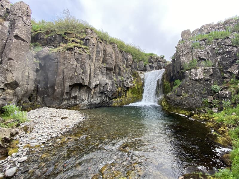
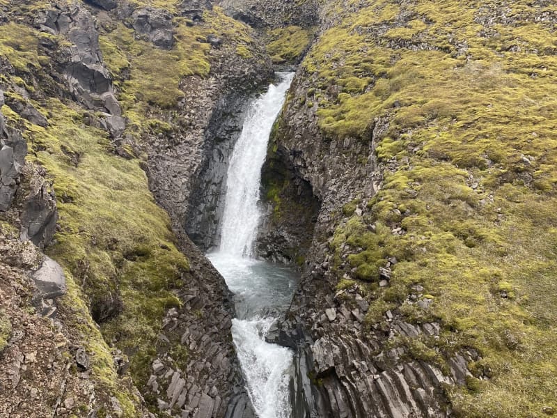
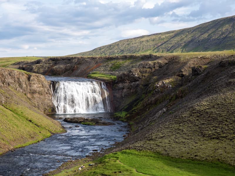
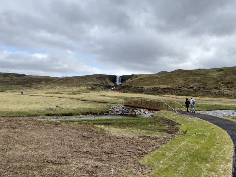
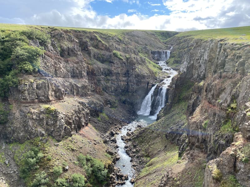
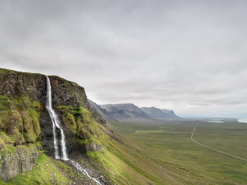
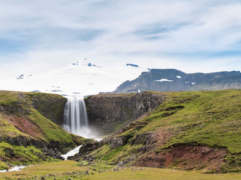
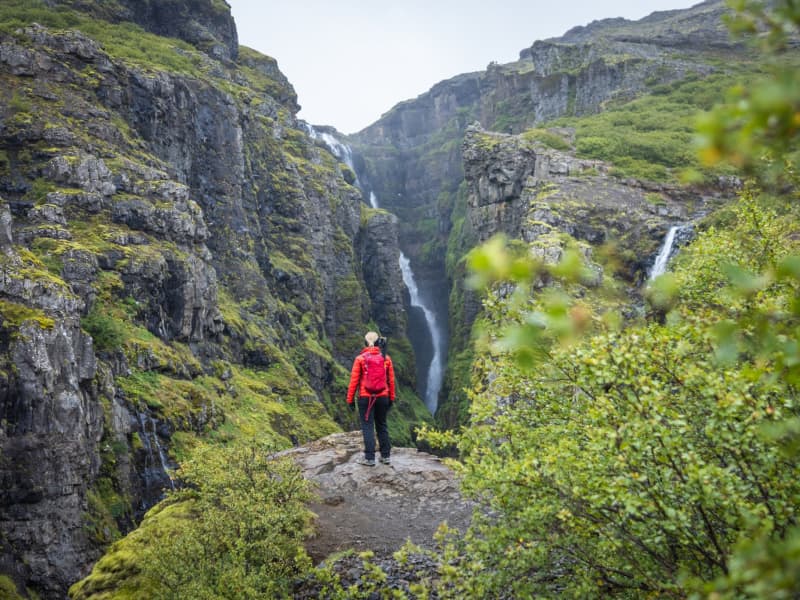
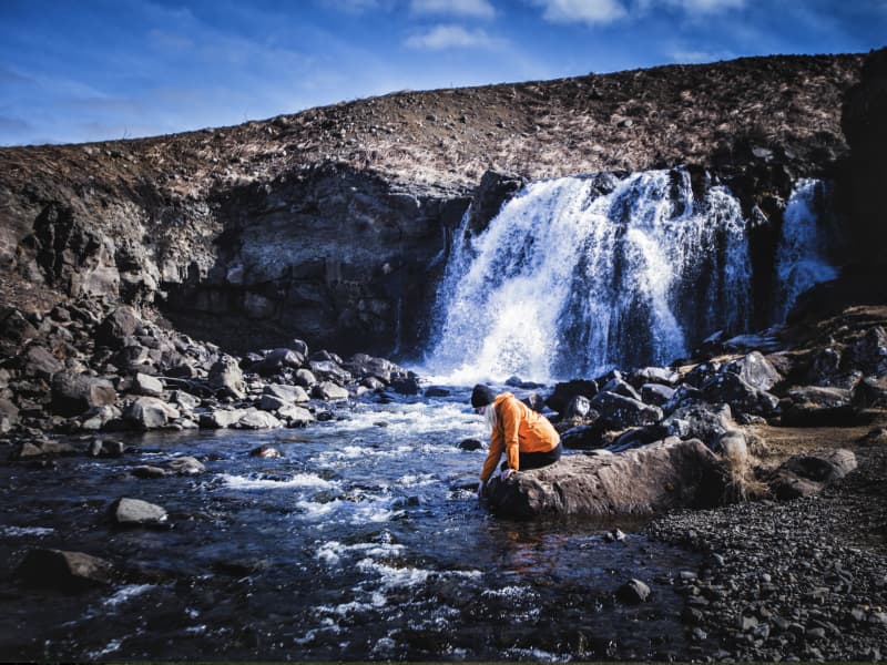
The Fossá forestry is located next to the highway nr. 47 and the rest stop at the outskirts of forestry has a great attraction of tourists around the area, but the view from there is excellent. The old structure used for sheep round- up and the waterfall, Sjávarfoss, attract a lot of attention when driving around the area as well as Hvalfjörður’s view.  
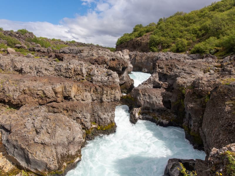
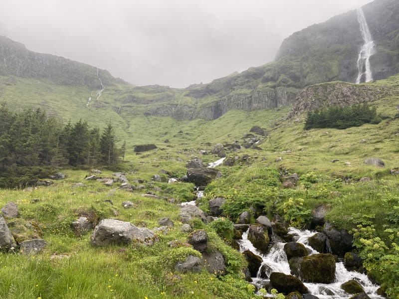
Fossá is a forestry area in Hvalfjörður that is managed by four forestry associations. Mosfellsbær Forestry Association, Kjalarnes, Kjós and Kópavogur. Fossá was officially incorporated into the Open Forest project in 2011. The Fossá area has a sheltered area and a lot of forest, but also has to offer mussel beaches off Fossárós, waterfalls and rapids that travel along the Fossá river and excellent berry land.  The land totals 1,100 hectares and over a million plantings have been planted being spruce, birch and pine mainly planted.  At Fossá you will find marked hiking trails as well as resting stops, and the area has great outdoor opportunities. The four forestry associations, established in 2001, a forestry management company over the land, and developments in the area where implemented such as path and roads and construction in the forest. This management company is called Fossá Forestry Company, which has its income from the sale of Christmas trees, but in recent years the sale of forest wood for various uses has also occurred. Christmas tree cultivation is important in the area and the management company has a good income from sales each year.  Area: Kjósahreppur.  Road number to the starting point: Hvalfjarðarvegur (nr. 47).   Level of difficulty: Easy way. There is accessibility for strollers and wheelchairs in many places, but not everywhere.  Length: 9.5km/ 5.71 miles.  Elevation: 50-100 meters/ 164- 328 ft elevation.  Markings: Signs are visible on parts of the trail, but in some places there are no markings.  Duration: 2 hours.  Route type: Small and big rocks, grass.   Obstacles on the way: Steps and wades.  Services in the area: No services.  Illumination: No illumination.  Season: The hiking trail is open all year round.  GPS coordinates to the starting point: N 64°21.1996 W 021°27.9139  GPS coordinates to the finishing point: N 64°21.1996 W 021°27.9139 
Rauðsgil hiking trail
Rauðsgil gorge in Borgarfjörður is on the border between Hálsasveit and Reyholtshrepss. The gorge is deepest at the bottom of the river, as it reaches from 60 to 70 meters deep but becomes shallower as it gets higher up the river. There are large number of waterfalls in the river, including Laxfoss, Einiberjafoss, Tröllafoss and Bæjarfoss waterfalls. The first part of the trail gives hikers a view of high waterfalls, with options to walk along the edge but also on a visable trail further from the edge. As hikers get upriver, the experience of the tranquililty and closeness to the river and waterfalls is breathtaking. Rauðsgil gorge is a little known place for domestic and foreign tourists that can be a good addition to the nature experience that is available in this area. The experience of visitors who visit and hike Rauðsgil gorge can be great, with the views of the mountain range around Rauðsgil, along with the sounds of the waterfalls. The hike is relatively easy, but there is no climbing along the trail but visitors can choose between the tractor trail further from the gorge or closer to the gorge, but visitor must be aware of the risks if the terrain is slippery or wet. Visitors with dogs are kindly asked to keep them on a leash when the sheep is free in the area, between 1st of June and 30th of September. Larger cars or buses are directed to Rauðsgilsrétt. Area: Rauðsgil, Borgarbyggð Road number to the starting point: Gravel pit near Steindórsstaðir farm (road no. 5150). Level of difficulty: Moderate. Length: 4.16km. Elevation: 252 meters. Markings: No markings. Duration: 1 hour and 21 minutes. Route type: Small stones, large stones and grass. Obstacles on the way: There are steps on the way. Services in the area: No service in the area. Illumination: No illumination on the hiking trail. Season: This hiking trail is open all year round but it is advised that the trail may be slippery due to ice during winter and the area is wet with mud during March until May. The trail is open all year round except when the sheep are herded from the slopes and mountains. 1-2 days a year in September. Informations are by the gate.  GPS coordinates starting- and finish point: N64°39.3434 W021°13.7068 
Fossá waterfall
Beautiful waterfall by the road. Nice spot to enjoy nature
Þórufoss Waterfall in Kjós
Þórufoss waterfall is in the river Laxá in Kjós which is renowned for its healthy population of Atlantic salmon. Þórufoss is known to freeze over in the wintertime. It´s easy to walk to the waterfall from the parking lot which is located right next to road nr. 48. The waterfall was a shooting location for HBO's Game of Thrones as the home of the Children of the Forest 
Svöðufoss waterfall walking path
Svöðufoss in Snæfellsnes is a beautiful waterfall in Hólmkelsá, not far from the town Rif. The waterfall is 10 meters high and falls from a beautiful basalt pillar rock. A parking lot has been built in the vicinity of the waterfall, mats-and iron walking paths have been installed to give access to strollers and weelchairs, all the way to the waterfall.   Area: Snæfellsnes (between Rif and Ólafsvík).  Road number to the starting point: Útnesvegur (no. 574) and turn to the Svöðufoss waterfall.  Level of difficulty: Easy  Length: 1.18km  Elevation: 20 meters.  Markings: No markings.  Duration: 17 minutes.  Route type: Mats-and iron walking paths.  Obstacles on the way: No obstacles.  Services in the area: No service.  Illumination: No illumination.  Season: The route is open all year round.  GSP coordinates start-and ending: N64°54.0155 W 023°48.6369  
Bjarnarfoss Waterfall
Bjarnarfoss is a majestic waterfall that falls down a basalt cliff which was formed by the now extinct volcano Maelifell. The waterfall, along with the columnar rocks around it, is on the Nature Conservation Register. A car park is near the waterfall and a good walking path. In 2018, the tourist attraction at Bjarnarfoss received the Icelandic Tourist Board´s environmental awards. 
Kirkjufellsfoss, waterfall, in Snaefellsnes
the most photographed waterfalls in Iceland. It is located near Grundarfjörður at the northern side of the Snæfellsnes Peninsula in West Iceland.